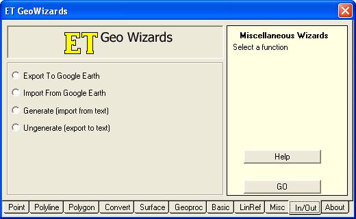
The installation package also includes an ET GeoWizards toolbox (.tbx) that contains tools that can be used in Model Builder and Command Line. For a complete list of free tools on both the GUI and in the toolbox, see the Free functions of ET GeoWizards page.
Below are *just a few* functions with descriptions from each tabbed group on the GUI that I personally have found useful. Definitely check out the complete list to see all of the free tools available.
Point
• Clean Point Layer – Deletes duplicate points.
• Measure Points – Assigns measures (M) or elevations (Z) to points based on interpolated values from the closest polyline within a user specified search tolerance.
• Reverse Geocoding – Uses a reference polyline layer to assign assign addresses to points of a point layer.
 |
Polyline
• Clean Polyline Layer – Ensures topological correctness of polyline features.
• Get Z Characteristics – Calculates several Z dimension characteristics and stores them in fields added to the attribute table. Includes characteristics such as 2D and 3D length of the polyline, min and max Z values, and average and max slow uphill and downhill among others.
• Flip Polylines – Assigns the node closest to a specified start point as the from node so that the direction of all polyline features point away from the start point.
 |
Polygon
• Clean Polygons – Ensures topological correctness of polygon features.
• Create Centerlines – Creates centerlines from polygon features. Can be created inside polygons (from polygon rivers and streets) our outside polygons (from parcel data).
• Get Adjacent Polygons – Stores the adjacent polygon names/IDs (user specified) as a comma delimited string as well as the count (number of adjacent polygons) for each polygon in the attribute table.
 |
Convert
• Polyline to Point – Converts a polyline dataset to a point dataset at 1) vertices, 2) nodes, or 3) mid points.
• Point to Multipoint – Converts a point layer to a multipoint dataset.
• Point to Point Z (M) – Uses a numeric field to assign values to the Z or M dimensions.
• Polygon Z (M) to Point – Converts polygon vertices to points and adds attributes to store Z and/or M values of each vertex.
• Polyline Z (M) to Point – Converts polyline vertices to points and adds attributes to store Z and/or M values of each vertex.
Surface
• Build TIN – Builds a Triangulated Irregular Network from a point, polyline, or polygon feature layer.
• Features to 3D – Creates a 3D dataset from point, polyline, or polygon features by deriving the values from a surface (Raster or TIN) layer.
 |
Geoproc
• Transfer Attributes – Transfers attributes from one polygon layer (source) to another (target) based on their spatial location.
• Spider Diagram (Spatial Location) – Creates a Spider Diagram representing the shortest distance between the points of a Center Points layer and the features in the destination layer (points, polylines, or polygons).
• Spider Diagram (Attribute Link) – Creates a Spider Diagram between the points of a Center Points layer and the features in the destination layer (points, polylines, or polygons) based on a common value in a user specified field in both layers.
 |
Basic
• Redefine Fields – Change field names, length, precision, and scale.
• Order Fields – Exports a feature layer to a new feature class. The user selects the fields to be exported and the order in which they will appear in the attribute table.
• Vector Grid – Creates a polygon or polyline grid with user defined extents and cell size.
 |
LinRef
• Create routes from existing polylines – Creates routes from existing polyline features. Input polylines that share a common identifier are merged to create a single route.
• Calibrate routes with points – Calibrates existing routes using the measures of existing points. The measures collected from the points can be M dimension values or can be stored in a ield of the point attribute table.
• Locate point features along routes – Finds the route and measure information of point features and creates a point event table. Search tolerance is used to correctly identify the closest routes to each point.
• Locate polygon features along routes – Calculates route and measure information at the geometric intersection of polygon data and route data and creates a line event table.
 |
Misc
• Features To Envelopes – Creates a polygon from the envelope of each feature in the input feature class. Attributes of the original features are transferred to the envelope polygons.
• Features To Minimum Bounding Circles – Creates a circular bounding polygon from each feature in the input feature class. Attributes of the original features are transferred to the resulting polygons.
• Create Station Lines – Creates station lines along the polyline features of the input layer. The station lines are perpendicular to the original polylines with user specified station distance and length. The length can be constant or calculated from Z or M values (if the input layer has Z or M values).
 |
In/Out
• Export To Google Earth – Converts all visible layers in a data frame to a Google Earth KML file.
• Import From Google Earth – Converts Google Earth (KML or KMZ) data in to feature classes.


